Team Name
Raytheon Team
Timeline
Summer 2021 – Fall 2021
Students
- Daniel Tam
- Joell Soriano
- Joshua Pearson
- Renato Cruel Amado
- Tiffany Frias
Sponsor
Raytheon
Abstract
The project was designed in order to capture wireless signals with sensors attached to a drone and display an altered reality (AR) Wi-Fi bubble with location derived from the triangulated data on a Microsoft HoloLens.
Background
The background for this project is to be able to visualize wireless networks in a simple; wearable alternate reality device. This can be used to gather information about existing networks such as SSID and signal strength. The device can also assist users visualize access points for a wireless network as well as determine if there is redundancy in the system. In an alternate case, the device can be used in a neighborhood setting providing information about the wireless networks available within proximity.
Project Requirements
- System Requirements
- Computer running Windows 10
- Drone
- Microsoft HoloLens 2
- Raspberry Pi
- Unity
- Functionality Requirements
- Collect the Raspberry Pi data and send to a data file.
- RF signals data file will be processed wireless signals and relative strength.
- Provide an interface that will allow users to see and select information about wireless signals.
- Client Requirements
- Display wireless signals as domes and their respective metadata.
- Display a 2D map of the environment.
- Display an AR environment that is mapped to GPS coordinates.
- User shall be able to click on signals to learn more.
System Overview
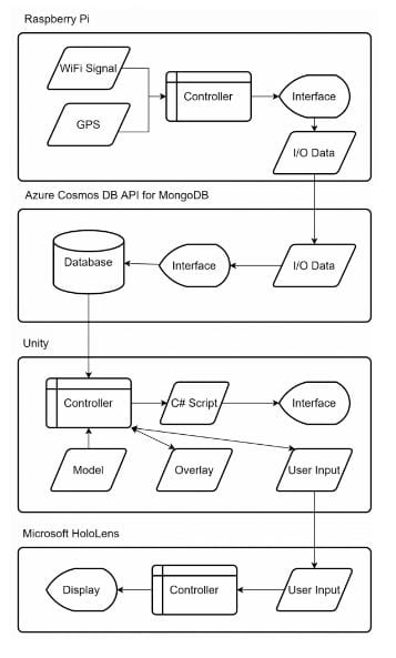
The real-world wireless signal data and GPS coordinates are collected by the Raspberry Pi using a drone. The Raspberry Pi data is sent to a database. The database will store the data to be pulled into Unity and process it into visual domes that indicate the coverage range of each network. Once we have the graphic data, this data will be mapped to the Microsoft HoloLens to display the AR environment.

Results
The team successfully created proof of concepts as to how wireless network domes would be visualized in the Hololens 2 and collected wireless network data on a Raspberry Pi around the ERB to then complete an end-to-end data transfer starting from the pi to a SQL database to the Unity platform. From there, the team plotted wireless network domes for every network found but were still working on the location and strength accuracies of the domes. A final demonstration video was created from outside the Engineering Research Building.
Future Work
- Add a drone.
- Gather the data at real-time speeds.
- Calculate wireless signals and process for real-time AR viewing.
- Differentiate wireless signals with color coding.